Distance from Slough to Sunderland
Distance between Slough and Sunderland is 381 kilometers (237 miles).
Driving distance from Slough to Sunderland is 448 kilometers (278 miles).
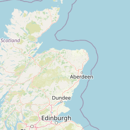
Distance Map Between Slough and Sunderland
Slough, London, United Kingdom ↔ Sunderland, London, United Kingdom = 237 miles = 381 km.


How far is it between Slough and Sunderland
Slough is located in United Kingdom with (51.5095,-0.5954) coordinates and Sunderland is located in United Kingdom with (54.9047,-1.3822) coordinates. The calculated flying distance from Slough to Sunderland is equal to 237 miles which is equal to 381 km.
If you want to go by car, the driving distance between Slough and Sunderland is 448.07 km. If you ride your car with an average speed of 112 kilometers/hour (70 miles/h), travel time will be 04 hours 00 minutes. Please check the avg. speed travel time table on the right for various options.
Difference between fly and go by a car is 67 km.
| City/Place | Latitude and Longitude | GPS Coordinates |
|---|---|---|
| Slough | 51.5095, -0.5954 | 51° 30´ 34.1640'' N 0° 35´ 43.4760'' W |
| Sunderland | 54.9047, -1.3822 | 54° 54´ 16.7400'' N 1° 22´ 55.9920'' W |
Estimated Travel Time Between Slough and Sunderland
| Average Speed | Travel Time |
|---|---|
| 30 mph (48 km/h) | 09 hours 20 minutes |
| 40 mph (64 km/h) | 07 hours 00 minutes |
| 50 mph (80 km/h) | 05 hours 36 minutes |
| 60 mph (97 km/h) | 04 hours 37 minutes |
| 70 mph (112 km/h) | 04 hours 00 minutes |
| 75 mph (120 km/h) | 03 hours 44 minutes |
Related Distances from Slough
| Cities | Distance |
|---|---|
| Slough to Windsor 3 | 8 km |
| Slough to Swindon | 96 km |
| Slough to Southall | 18 km |
| Slough to Southampton | 102 km |
| Slough to Watford | 38 km |
Related Distances to Sunderland
| Cities | Distance |
|---|---|
| Newcastle Upon Tyne to Sunderland | 23 km |
| City Of London to Sunderland | 452 km |
| Manchester to Sunderland | 219 km |
| Birmingham to Sunderland | 323 km |
| Middlesbrough to Sunderland | 48 km |