Distance from Smyrna to Macon
Distance between Smyrna and Macon is 142 kilometers (88 miles).
Driving distance from Smyrna to Macon is 161 kilometers (100 miles).
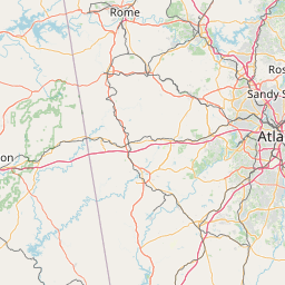
Distance Map Between Smyrna and Macon
Smyrna, Atlanta, United States ↔ Macon, Atlanta, United States = 88 miles = 142 km.


How far is it between Smyrna and Macon
Smyrna is located in United States with (33.884,-84.5144) coordinates and Macon is located in United States with (32.8407,-83.6324) coordinates. The calculated flying distance from Smyrna to Macon is equal to 88 miles which is equal to 142 km.
If you want to go by car, the driving distance between Smyrna and Macon is 161.15 km. If you ride your car with an average speed of 112 kilometers/hour (70 miles/h), travel time will be 01 hours 26 minutes. Please check the avg. speed travel time table on the right for various options.
Difference between fly and go by a car is 19 km.
| City/Place | Latitude and Longitude | GPS Coordinates |
|---|---|---|
| Smyrna | 33.884, -84.5144 | 33° 53´ 2.3640'' N 84° 30´ 51.7680'' W |
| Macon | 32.8407, -83.6324 | 32° 50´ 26.4840'' N 83° 37´ 56.6400'' W |
Estimated Travel Time Between Smyrna and Macon
| Average Speed | Travel Time |
|---|---|
| 30 mph (48 km/h) | 03 hours 21 minutes |
| 40 mph (64 km/h) | 02 hours 31 minutes |
| 50 mph (80 km/h) | 02 hours 00 minutes |
| 60 mph (97 km/h) | 01 hours 39 minutes |
| 70 mph (112 km/h) | 01 hours 26 minutes |
| 75 mph (120 km/h) | 01 hours 20 minutes |
Related Distances from Smyrna
| Cities | Distance |
|---|---|
| Smyrna to Sandy Springs | 18 km |
| Smyrna to Riverdale | 44 km |
| Smyrna to Athens 2 | 121 km |
| Smyrna to Canton 3 | 50 km |
| Smyrna to Dunwoody | 24 km |
Related Distances to Macon
| Cities | Distance |
|---|---|
| Savannah to Macon | 266 km |
| Valdosta to Macon | 244 km |
| Milledgeville to Macon | 49 km |
| Mcdonough to Macon | 91 km |
| North Atlanta to Macon | 152 km |