Distance from Socastee to Reynosa
Distance between Socastee and Reynosa is 2039 kilometers (1267 miles).
Driving distance from Socastee to Reynosa is 2422 kilometers (1505 miles).
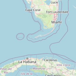
Distance Map Between Socastee and Reynosa
Socastee, Columbia, United States ↔ Reynosa, Ciudad Victoria, Mexico = 1267 miles = 2039 km.


How far is it between Socastee and Reynosa
Socastee is located in United States with (33.6835,-78.9984) coordinates and Reynosa is located in Mexico with (26.0768,-98.2975) coordinates. The calculated flying distance from Socastee to Reynosa is equal to 1267 miles which is equal to 2039 km.
If you want to go by car, the driving distance between Socastee and Reynosa is 2422.1 km. If you ride your car with an average speed of 112 kilometers/hour (70 miles/h), travel time will be 21 hours 37 minutes. Please check the avg. speed travel time table on the right for various options.
Difference between fly and go by a car is 383 km.
| City/Place | Latitude and Longitude | GPS Coordinates |
|---|---|---|
| Socastee | 33.6835, -78.9984 | 33° 41´ 0.6000'' N 78° 59´ 54.1320'' W |
| Reynosa | 26.0768, -98.2975 | 26° 4´ 36.5160'' N 98° 17´ 50.9280'' W |
Estimated Travel Time Between Socastee and Reynosa
| Average Speed | Travel Time |
|---|---|
| 30 mph (48 km/h) | 50 hours 27 minutes |
| 40 mph (64 km/h) | 37 hours 50 minutes |
| 50 mph (80 km/h) | 30 hours 16 minutes |
| 60 mph (97 km/h) | 24 hours 58 minutes |
| 70 mph (112 km/h) | 21 hours 37 minutes |
| 75 mph (120 km/h) | 20 hours 11 minutes |
Related Distances from Socastee
| Cities | Distance |
|---|---|
| Socastee to Santa Maria Chimalhuacan | 3459 km |
| Socastee to Merida | 4411 km |
| Socastee to Cancun | 4689 km |
| Socastee to Gustavo A Madero 2 | 2841 km |
| Socastee to Puebla | 3573 km |
Related Distances to Reynosa
| Cities | Distance |
|---|---|
| Houston to Reynosa | 581 km |
| Fort Worth to Reynosa | 819 km |
| Hutchinson to Reynosa | 1476 km |
| Dallas to Reynosa | 834 km |
| El Paso to Reynosa | 1290 km |