Distance from State College to Altoona
Distance between State College and Altoona is 54 kilometers (34 miles).
Driving distance from State College to Altoona is 72 kilometers (45 miles).
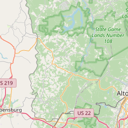
Distance Map Between State College and Altoona
State College, Harrisburg, United States ↔ Altoona, Harrisburg, United States = 34 miles = 54 km.


How far is it between State College and Altoona
State College is located in United States with (40.7934,-77.86) coordinates and Altoona is located in United States with (40.5187,-78.3947) coordinates. The calculated flying distance from State College to Altoona is equal to 34 miles which is equal to 54 km.
If you want to go by car, the driving distance between State College and Altoona is 72.08 km. If you ride your car with an average speed of 112 kilometers/hour (70 miles/h), travel time will be 00 hours 38 minutes. Please check the avg. speed travel time table on the right for various options.
Difference between fly and go by a car is 18 km.
| City/Place | Latitude and Longitude | GPS Coordinates |
|---|---|---|
| State College | 40.7934, -77.86 | 40° 47´ 36.2040'' N 77° 51´ 36.0000'' W |
| Altoona | 40.5187, -78.3947 | 40° 31´ 7.2480'' N 78° 23´ 41.0640'' W |
Estimated Travel Time Between State College and Altoona
| Average Speed | Travel Time |
|---|---|
| 30 mph (48 km/h) | 01 hours 30 minutes |
| 40 mph (64 km/h) | 01 hours 07 minutes |
| 50 mph (80 km/h) | 00 hours 54 minutes |
| 60 mph (97 km/h) | 00 hours 44 minutes |
| 70 mph (112 km/h) | 00 hours 38 minutes |
| 75 mph (120 km/h) | 00 hours 36 minutes |
Related Distances from State College
| Cities | Distance |
|---|---|
| State College to Altoona | 72 km |
| State College to Philadelphia | 309 km |
| State College to Pittsburgh | 225 km |
| State College to Lancaster 2 | 201 km |
| State College to Chambersburg | 145 km |
Related Distances to Altoona
| Cities | Distance |
|---|---|
| State College to Altoona | 72 km |
| Pittsburgh to Altoona | 158 km |
| Johnstown to Altoona | 70 km |
| Carlisle 2 to Altoona | 196 km |
| Erie to Altoona | 326 km |