Distance from Syracuse to Millcreek
Distance between Syracuse and Millcreek is 47 kilometers (30 miles).
Driving distance from Syracuse to Millcreek is 58 kilometers (36 miles).
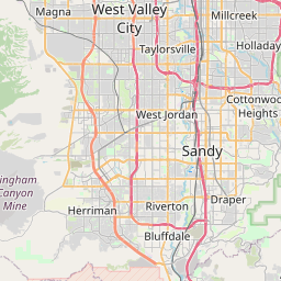
Distance Map Between Syracuse and Millcreek
Syracuse, Salt Lake City, United States ↔ Millcreek, Salt Lake City, United States = 30 miles = 47 km.


How far is it between Syracuse and Millcreek
Syracuse is located in United States with (41.0894,-112.0647) coordinates and Millcreek is located in United States with (40.6869,-111.8755) coordinates. The calculated flying distance from Syracuse to Millcreek is equal to 30 miles which is equal to 47 km.
If you want to go by car, the driving distance between Syracuse and Millcreek is 58.06 km. If you ride your car with an average speed of 112 kilometers/hour (70 miles/h), travel time will be 00 hours 31 minutes. Please check the avg. speed travel time table on the right for various options.
Difference between fly and go by a car is 11 km.
| City/Place | Latitude and Longitude | GPS Coordinates |
|---|---|---|
| Syracuse | 41.0894, -112.0647 | 41° 5´ 21.8040'' N 112° 3´ 52.8120'' W |
| Millcreek | 40.6869, -111.8755 | 40° 41´ 12.8040'' N 111° 52´ 31.7640'' W |
Estimated Travel Time Between Syracuse and Millcreek
| Average Speed | Travel Time |
|---|---|
| 30 mph (48 km/h) | 01 hours 12 minutes |
| 40 mph (64 km/h) | 00 hours 54 minutes |
| 50 mph (80 km/h) | 00 hours 43 minutes |
| 60 mph (97 km/h) | 00 hours 35 minutes |
| 70 mph (112 km/h) | 00 hours 31 minutes |
| 75 mph (120 km/h) | 00 hours 29 minutes |
Related Distances from Syracuse
| Cities | Distance |
|---|---|
| Syracuse 2 to Saratoga Springs 2 | 97 km |
| Syracuse 2 to Bountiful | 32 km |
| Syracuse 2 to Ogden | 22 km |
| Syracuse 2 to Layton | 10 km |
| Syracuse 2 to Clinton 5 | 7 km |
Related Distances to Millcreek
| Cities | Distance |
|---|---|
| Murray to Millcreek | 3 km |
| Ogden to Millcreek | 71 km |
| West Valley City to Millcreek | 12 km |
| Sandy City to Millcreek | 15 km |
| Taylorsville to Millcreek | 8 km |