Distance from Tomobe to Koga
Distance between Tomobe and Koga is 55 kilometers (34 miles).
Driving distance from Tomobe to Koga is 70 kilometers (44 miles).
Distance Map Between Tomobe and Koga
Tomobe, Mito-shi, Japan ↔ Koga, Mito-shi, Japan = 34 miles = 55 km.


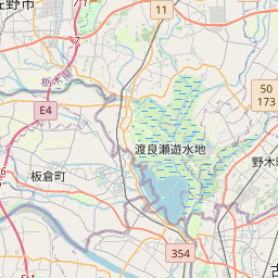


Leaflet | © OpenStreetMap
How far is it between Tomobe and Koga
Tomobe is located in Japan with (36.35,140.3) coordinates and Koga is located in Japan with (36.1833,139.7167) coordinates. The calculated flying distance from Tomobe to Koga is equal to 34 miles which is equal to 55 km.
If you want to go by car, the driving distance between Tomobe and Koga is 70.32 km. If you ride your car with an average speed of 112 kilometers/hour (70 miles/h), travel time will be 00 hours 37 minutes. Please check the avg. speed travel time table on the right for various options.
Difference between fly and go by a car is 15 km.
| City/Place | Latitude and Longitude | GPS Coordinates |
|---|---|---|
| Tomobe | 36.35, 140.3 | 36° 21´ 0.0000'' N 140° 18´ 0.0000'' E |
| Koga | 36.1833, 139.7167 | 36° 10´ 59.9880'' N 139° 43´ 0.0120'' E |
Estimated Travel Time Between Tomobe and Koga
| Average Speed | Travel Time |
|---|---|
| 30 mph (48 km/h) | 01 hours 27 minutes |
| 40 mph (64 km/h) | 01 hours 05 minutes |
| 50 mph (80 km/h) | 00 hours 52 minutes |
| 60 mph (97 km/h) | 00 hours 43 minutes |
| 70 mph (112 km/h) | 00 hours 37 minutes |
| 75 mph (120 km/h) | 00 hours 35 minutes |
Tomobe, Mito-shi, Japan
Related Distances from Tomobe
| Cities | Distance |
|---|---|
| Tomobe to Tsukuba | 45 km |
| Tomobe to Kashima Shi | 69 km |
| Tomobe to Iwai | 80 km |
| Tomobe to Yuki | 45 km |
| Tomobe to Shimodate | 34 km |
Koga, Mito-shi, Japan
Related Distances to Koga
| Cities | Distance |
|---|---|
| Iwai to Koga 2 | 25 km |
| Ami to Koga 2 | 60 km |
| Hitachi to Koga 2 | 121 km |
| Omiya to Koga 2 | 110 km |
| Toride to Koga 2 | 53 km |