Distance from Waco to Pflugerville
Distance between Waco and Pflugerville is 131 kilometers (82 miles).
Driving distance from Waco to Pflugerville is 145 kilometers (90 miles).
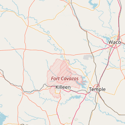
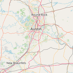
Distance Map Between Waco and Pflugerville
Waco, Austin, United States ↔ Pflugerville, Austin, United States = 82 miles = 131 km.


How far is it between Waco and Pflugerville
Waco is located in United States with (31.5493,-97.1467) coordinates and Pflugerville is located in United States with (30.4394,-97.62) coordinates. The calculated flying distance from Waco to Pflugerville is equal to 82 miles which is equal to 131 km.
If you want to go by car, the driving distance between Waco and Pflugerville is 145.15 km. If you ride your car with an average speed of 112 kilometers/hour (70 miles/h), travel time will be 01 hours 17 minutes. Please check the avg. speed travel time table on the right for various options.
Difference between fly and go by a car is 14 km.
| City/Place | Latitude and Longitude | GPS Coordinates |
|---|---|---|
| Waco | 31.5493, -97.1467 | 31° 32´ 57.5880'' N 97° 8´ 48.0120'' W |
| Pflugerville | 30.4394, -97.62 | 30° 26´ 21.7320'' N 97° 37´ 12.0000'' W |
Estimated Travel Time Between Waco and Pflugerville
| Average Speed | Travel Time |
|---|---|
| 30 mph (48 km/h) | 03 hours 01 minutes |
| 40 mph (64 km/h) | 02 hours 16 minutes |
| 50 mph (80 km/h) | 01 hours 48 minutes |
| 60 mph (97 km/h) | 01 hours 29 minutes |
| 70 mph (112 km/h) | 01 hours 17 minutes |
| 75 mph (120 km/h) | 01 hours 12 minutes |
Related Distances from Waco
| Cities | Distance |
|---|---|
| Waco to Abilene | 297 km |
| Waco to Alamo 2 | 666 km |
| Waco to Aldine | 295 km |
| Waco to Alice | 483 km |
| Waco to Allen | 194 km |
| Waco to Alvin | 345 km |
| Waco to Angleton | 364 km |
| Waco to Arlington | 164 km |
| Waco to Atascocita | 312 km |
| Waco to Balch Springs | 159 km |
Related Distances to Pflugerville
| Cities | Distance |
|---|---|
| El Paso to Pflugerville | 957 km |
| Temple to Pflugerville | 91 km |
| Sugar Land to Pflugerville | 266 km |
| Texarkana to Pflugerville | 584 km |
| Tyler to Pflugerville | 350 km |
| Port Arthur to Pflugerville | 395 km |
| Uvalde to Pflugerville | 307 km |
| San Marcos 3 to Pflugerville | 77 km |
| Seguin to Pflugerville | 120 km |
| Spring to Pflugerville | 244 km |