Distance from Weesp to Brussels
Distance between Weesp and Brussels is 169 kilometers (105 miles).
Driving distance from Weesp to Brussels is 198 kilometers (123 miles).
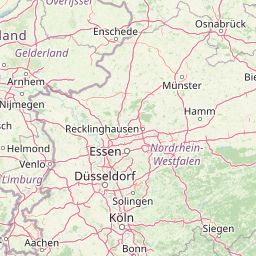
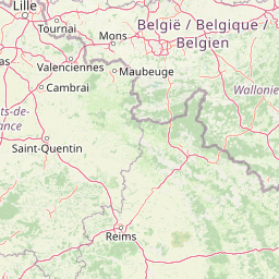
Distance Map Between Weesp and Brussels
Weesp, Haarlem, Netherlands ↔ Brussels, Belgium = 105 miles = 169 km.


How far is it between Weesp and Brussels
Weesp is located in Netherlands with (52.3075,5.0417) coordinates and Brussels is located in Belgium with (50.8505,4.3488) coordinates. The calculated flying distance from Weesp to Brussels is equal to 105 miles which is equal to 169 km.
If you want to go by car, the driving distance between Weesp and Brussels is 197.87 km. If you ride your car with an average speed of 112 kilometers/hour (70 miles/h), travel time will be 01 hours 46 minutes. Please check the avg. speed travel time table on the right for various options.
Difference between fly and go by a car is 29 km.
| City/Place | Latitude and Longitude | GPS Coordinates |
|---|---|---|
| Weesp | 52.3075, 5.0417 | 52° 18´ 27.0000'' N 5° 2´ 30.0120'' E |
| Brussels | 50.8505, 4.3488 | 50° 51´ 1.6200'' N 4° 20´ 55.6080'' E |
Estimated Travel Time Between Weesp and Brussels
| Average Speed | Travel Time |
|---|---|
| 30 mph (48 km/h) | 04 hours 07 minutes |
| 40 mph (64 km/h) | 03 hours 05 minutes |
| 50 mph (80 km/h) | 02 hours 28 minutes |
| 60 mph (97 km/h) | 02 hours 02 minutes |
| 70 mph (112 km/h) | 01 hours 46 minutes |
| 75 mph (120 km/h) | 01 hours 38 minutes |
Related Distances to Brussels
| Cities | Distance |
|---|---|
| Amsterdam to Brussels | 209 km |
| Eindhoven to Brussels | 129 km |
| Maastricht to Brussels | 111 km |
| Rotterdam to Brussels | 143 km |
| The Hague to Brussels | 173 km |