Distance from West Chicago to Decatur
Distance between West Chicago and Decatur is 236 kilometers (147 miles).
Driving distance from West Chicago to Decatur is 288 kilometers (179 miles).
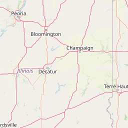
Distance Map Between West Chicago and Decatur
West Chicago, Springfield, United States ↔ Decatur, Springfield, United States = 147 miles = 236 km.


How far is it between West Chicago and Decatur
West Chicago is located in United States with (41.8848,-88.204) coordinates and Decatur is located in United States with (39.8403,-88.9548) coordinates. The calculated flying distance from West Chicago to Decatur is equal to 147 miles which is equal to 236 km.
If you want to go by car, the driving distance between West Chicago and Decatur is 287.62 km. If you ride your car with an average speed of 112 kilometers/hour (70 miles/h), travel time will be 02 hours 34 minutes. Please check the avg. speed travel time table on the right for various options.
Difference between fly and go by a car is 52 km.
| City/Place | Latitude and Longitude | GPS Coordinates |
|---|---|---|
| West Chicago | 41.8848, -88.204 | 41° 53´ 5.1000'' N 88° 12´ 14.2560'' W |
| Decatur | 39.8403, -88.9548 | 39° 50´ 25.1160'' N 88° 57´ 17.2800'' W |
Estimated Travel Time Between West Chicago and Decatur
| Average Speed | Travel Time |
|---|---|
| 30 mph (48 km/h) | 05 hours 59 minutes |
| 40 mph (64 km/h) | 04 hours 29 minutes |
| 50 mph (80 km/h) | 03 hours 35 minutes |
| 60 mph (97 km/h) | 02 hours 57 minutes |
| 70 mph (112 km/h) | 02 hours 34 minutes |
| 75 mph (120 km/h) | 02 hours 23 minutes |
Related Distances from West Chicago
| Cities | Distance |
|---|---|
| West Chicago to Oak Park | 52 km |
| West Chicago to Elk Grove Village | 32 km |
| West Chicago to Carol Stream | 8 km |
| West Chicago to Lisle | 18 km |
| West Chicago to Hoffman Estates | 27 km |
Related Distances to Decatur
| Cities | Distance |
|---|---|
| Dunwoody to Decatur 3 | 25 km |
| Chicago to Decatur | 289 km |
| Marietta to Decatur 3 | 40 km |
| Sandy Springs to Decatur 3 | 29 km |
| Florence 2 to Decatur 2 | 79 km |