Distance from West Chicago to Normal
Distance between West Chicago and Normal is 166 kilometers (103 miles).
Driving distance from West Chicago to Normal is 207 kilometers (128 miles).
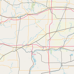
Distance Map Between West Chicago and Normal
West Chicago, Springfield, United States ↔ Normal, Springfield, United States = 103 miles = 166 km.


How far is it between West Chicago and Normal
West Chicago is located in United States with (41.8848,-88.204) coordinates and Normal is located in United States with (40.5142,-88.9906) coordinates. The calculated flying distance from West Chicago to Normal is equal to 103 miles which is equal to 166 km.
If you want to go by car, the driving distance between West Chicago and Normal is 206.55 km. If you ride your car with an average speed of 112 kilometers/hour (70 miles/h), travel time will be 01 hours 50 minutes. Please check the avg. speed travel time table on the right for various options.
Difference between fly and go by a car is 41 km.
| City/Place | Latitude and Longitude | GPS Coordinates |
|---|---|---|
| West Chicago | 41.8848, -88.204 | 41° 53´ 5.1000'' N 88° 12´ 14.2560'' W |
| Normal | 40.5142, -88.9906 | 40° 30´ 51.1200'' N 88° 59´ 26.2680'' W |
Estimated Travel Time Between West Chicago and Normal
| Average Speed | Travel Time |
|---|---|
| 30 mph (48 km/h) | 04 hours 18 minutes |
| 40 mph (64 km/h) | 03 hours 13 minutes |
| 50 mph (80 km/h) | 02 hours 34 minutes |
| 60 mph (97 km/h) | 02 hours 07 minutes |
| 70 mph (112 km/h) | 01 hours 50 minutes |
| 75 mph (120 km/h) | 01 hours 43 minutes |
Related Distances from West Chicago
| Cities | Distance |
|---|---|
| West Chicago to Oak Park | 52 km |
| West Chicago to Elk Grove Village | 32 km |
| West Chicago to Carol Stream | 8 km |
| West Chicago to Lisle | 18 km |
| West Chicago to Hoffman Estates | 27 km |
Related Distances to Normal
| Cities | Distance |
|---|---|
| Peoria 2 to Normal | 62 km |
| Rockford to Normal | 210 km |
| Plainfield 2 to Normal | 159 km |
| Tinley Park to Normal | 181 km |
| Pekin to Normal | 67 km |