Distance from Weston to Pensacola
Distance between Weston and Pensacola is 822 kilometers (511 miles).
Driving distance from Weston to Pensacola is 1068 kilometers (664 miles).
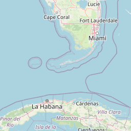
Distance Map Between Weston and Pensacola
Weston, Tallahassee, United States ↔ Pensacola, Tallahassee, United States = 511 miles = 822 km.


How far is it between Weston and Pensacola
Weston is located in United States with (26.1004,-80.3998) coordinates and Pensacola is located in United States with (30.4213,-87.2169) coordinates. The calculated flying distance from Weston to Pensacola is equal to 511 miles which is equal to 822 km.
If you want to go by car, the driving distance between Weston and Pensacola is 1067.83 km. If you ride your car with an average speed of 112 kilometers/hour (70 miles/h), travel time will be 09 hours 32 minutes. Please check the avg. speed travel time table on the right for various options.
Difference between fly and go by a car is 246 km.
| City/Place | Latitude and Longitude | GPS Coordinates |
|---|---|---|
| Weston | 26.1004, -80.3998 | 26° 6´ 1.3320'' N 80° 23´ 59.1720'' W |
| Pensacola | 30.4213, -87.2169 | 30° 25´ 16.7160'' N 87° 13´ 0.8760'' W |
Estimated Travel Time Between Weston and Pensacola
| Average Speed | Travel Time |
|---|---|
| 30 mph (48 km/h) | 22 hours 14 minutes |
| 40 mph (64 km/h) | 16 hours 41 minutes |
| 50 mph (80 km/h) | 13 hours 20 minutes |
| 60 mph (97 km/h) | 11 hours 00 minutes |
| 70 mph (112 km/h) | 09 hours 32 minutes |
| 75 mph (120 km/h) | 08 hours 53 minutes |
Related Distances from Weston
| Cities | Distance |
|---|---|
| Weston to Miami | 58 km |
| Weston to Fort Lauderdale | 38 km |
| Weston to Boca Raton | 61 km |
| Weston to Jupiter | 129 km |
| Weston to West Palm Beach | 101 km |
Related Distances to Pensacola
| Cities | Distance |
|---|---|
| West Palm Beach to Pensacola | 982 km |
| Sarasota to Pensacola | 838 km |
| Tampa to Pensacola | 754 km |
| The Villages to Pensacola | 647 km |
| Vero Beach to Pensacola | 877 km |