Distance from Wyckoff to Ewing
Distance between Wyckoff and Ewing is 98 kilometers (61 miles).
Driving distance from Wyckoff to Ewing is 128 kilometers (79 miles).
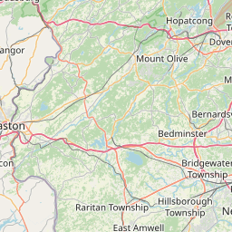
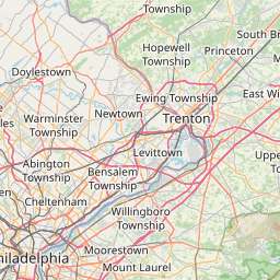
Distance Map Between Wyckoff and Ewing
Wyckoff, Trenton, United States ↔ Ewing, Trenton, United States = 61 miles = 98 km.


How far is it between Wyckoff and Ewing
Wyckoff is located in United States with (41.0095,-74.1729) coordinates and Ewing is located in United States with (40.2698,-74.7999) coordinates. The calculated flying distance from Wyckoff to Ewing is equal to 61 miles which is equal to 98 km.
If you want to go by car, the driving distance between Wyckoff and Ewing is 127.84 km. If you ride your car with an average speed of 112 kilometers/hour (70 miles/h), travel time will be 01 hours 08 minutes. Please check the avg. speed travel time table on the right for various options.
Difference between fly and go by a car is 30 km.
| City/Place | Latitude and Longitude | GPS Coordinates |
|---|---|---|
| Wyckoff | 41.0095, -74.1729 | 41° 0´ 34.3440'' N 74° 10´ 22.5120'' W |
| Ewing | 40.2698, -74.7999 | 40° 16´ 11.3880'' N 74° 47´ 59.5680'' W |
Estimated Travel Time Between Wyckoff and Ewing
| Average Speed | Travel Time |
|---|---|
| 30 mph (48 km/h) | 02 hours 39 minutes |
| 40 mph (64 km/h) | 01 hours 59 minutes |
| 50 mph (80 km/h) | 01 hours 35 minutes |
| 60 mph (97 km/h) | 01 hours 19 minutes |
| 70 mph (112 km/h) | 01 hours 08 minutes |
| 75 mph (120 km/h) | 01 hours 03 minutes |
Related Distances from Wyckoff
| Cities | Distance |
|---|---|
| Wyckoff to Teaneck | 22 km |
| Wyckoff to Summit | 53 km |
| Wyckoff to Garfield | 19 km |
| Wyckoff to North Bergen | 33 km |
| Wyckoff to Edison | 75 km |
Related Distances to Ewing
| Cities | Distance |
|---|---|
| Paramus to Ewing | 112 km |
| North Bergen to Ewing | 101 km |
| Jersey City to Ewing | 92 km |
| North Arlington to Ewing | 98 km |
| Kearny to Ewing | 94 km |