Distance from Yovon to Kabul
Distance between Yovon and Kabul is 421 kilometers (262 miles).
Distance Map Between Yovon and Kabul
Yovon, Qurghonteppa, Tajikistan ↔ Kabul, Afghanistan = 262 miles = 421 km.
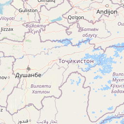


Leaflet | © OpenStreetMap
How far is it between Yovon and Kabul
Yovon is located in Tajikistan with (38.3141,69.0378) coordinates and Kabul is located in Afghanistan with (34.5281,69.1723) coordinates. The calculated flying distance from Yovon to Kabul is equal to 262 miles which is equal to 421 km.
| City/Place | Latitude and Longitude | GPS Coordinates |
|---|---|---|
| Yovon | 38.3141, 69.0378 | 38° 18´ 50.6880'' N 69° 2´ 16.2240'' E |
| Kabul | 34.5281, 69.1723 | 34° 31´ 41.2680'' N 69° 10´ 20.3880'' E |
Kabul, Afghanistan
Related Distances to Kabul
| Cities | Distance |
|---|---|
| Dushanbe to Kabul | 576 km |
| Khujand to Kabul | 877 km |
| Farkhor to Kabul | 524 km |
| Qurghonteppa to Kabul | 485 km |
| Khorugh to Kabul | 616 km |